

| NEW: Model 2 expands SediMeter use to the near-shore environment |
| Measures turbidity and sediment concentration through the water-bottom interface |
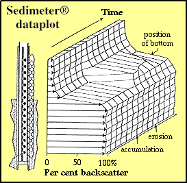
| The bottom level may be estimated with sub-millimetre resolution |
| The patented sensor design has been successfully used for many years |
| Pressure and light sensors are optional, temperature is standard |
| Both data logging and real-time monitoring is supported |
General
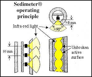
The SediMeter measures erosion and accumulation of sediments with a resolution of 0.1 mm or better. It can also be used to measure near-bed turbidity, which is intimately related to the sediment concentration.The sensor is a rod, 20 mm diameter, that is immersed into the bottom. Measurements are made using infra-red back-scatter detectors, to minimize the influence of ambient light.
If a specific detector is below bottom level, the signal level from that sensor approaches 100%. If it is far above the bottom level, the signal is a function of sediment concentration in the water. If it is close above the bottom, the signal is a function of both distance to the bottom, and sediment concentration. The user may adopt a calibration procedure to separate between those two influences.
Deployment
The SediMeter Model 2 is in the standard configuration equipped to be used on bottoms where there is at least 50 cm of sediments, allowing the mounting screw to be firmly fixed in the bottom.A diver screws down the holder, removes the handle, inserts the SediMeter, and locks it in place with the yellow screw. When it is time to recover the data and exchange battery, he can put another unit directly into the same holder, thus allowing a continuous measurement series to be made.
If a hole is drilled the holder tube can also be inserted on a hard-bottom. Even minute amounts of sedimentation may drastically change the reflectivity of the bottom, which is easily detected by the SediMeter since it effectively looks obliquely down on the bottom from a close distance.

Output
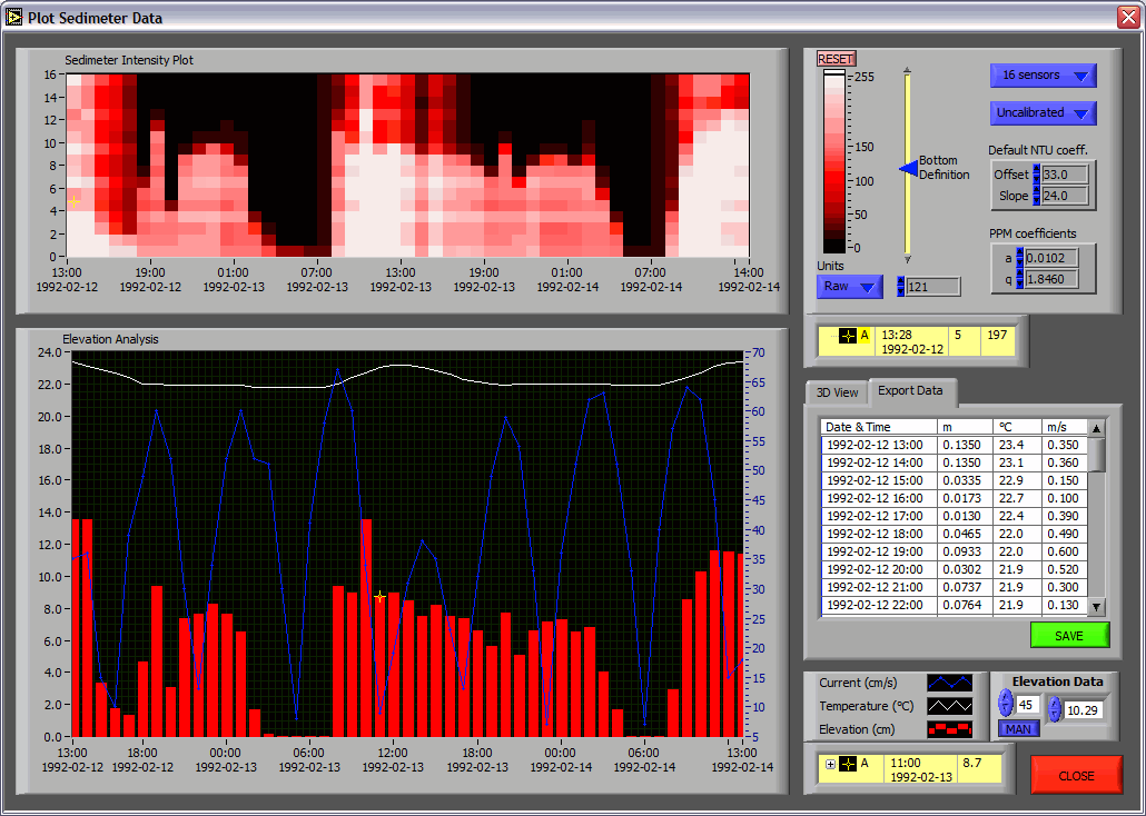
The SediMeter Model 2 employs the new LogDator™ controller. Data can be stored on the 2 MB built-in memory and retrieved via USB, or on a SD or MMC memory card. In the latter case data is stored in computer-readable files.Alternatively, the instrument can be operated remotely over an up to 1200 m long cable. Over 100 instruments can be connected along a single RS-485 cable.
PC software
A PC SediMeter software is included with each LogDator™. It allows the user to interactively analyze the data and create a file of bottom elevation as a function of time, from the recorded backscatter values.The software accepts formazin calibration coefficients. It means that the backscatter values can be presented in NTU units. Also the near-bed sediment concentration in PPM can be plotted. The program estimates the bottom elevation with 0.1 mm resolution, based on the criteria the user interactively chooses in either of the units raw data, NTU, or PPM.
The features incorporated in this software are based on the results presented in the links below.
Click to open image in new window